Earlier this week I went down to visit the construction of a new section of river course on a small tributary of the Eddleston Water, Tweed Catchment. The Tweed Forum (http://www.tweedforum.org/) are behind this development and are at the forefront of Natural Flood Management (NFM) in Scotland. Thankfully for me, they also provide me with a lot of help and advice for the Allan Water Catchment.
I arrived on site to meet with Hugh Chalmers of the Tweed Forum, who gave me a background to the site before we had a walk around it. Hugh informed me, that there were two separate sections of new river being created at this site. The two new river sections are split into one large section at the downstream end and one smaller section further upstream in a recently cleared conifer plantation. The reason that two sections were required instead of one large section is that one of the landowners had a very productive field beside the current channelised river that was too valuable to his business to have reduced in size. Being able to compromise with landowners and their businesses is a crucial part of NFM, and therefore the productive field and it’s section of river was left out of the remeandering project.
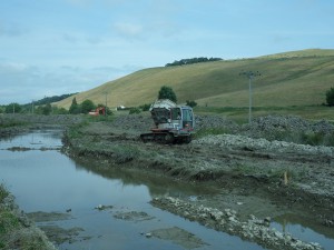
Currently, the majority of work to date had been carried out on the long downstream section. In this section the old channelised river course had been cut off with spoil and it’s water diverted, and fish, eels and lampreys had been removed and relocated downstream to reduce the environmental impact of the project. The water of the river was diverted down two farm drains either side of the old channelised course to join the river again outside of the project area. Having low water/dry channels in the old and new river courses allows for work to be carried out on both with more ease.
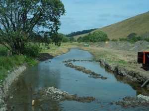
Thalweg marked with wooden stakes, gravel on the right bank, and beyond the willow tree, the new river banks profiled and landscaped
The new river course still needed large parts of it’s banks profiled and turfed so that the banks would not suffer erosion when connected to the river course again. Within the new river, the deepest part of it’s course (the thalweg) had been marked with wooden stakes for the river engineers to design a natural course. Lastly, a digger and dumper team was busy transporting gravel from the old river to the bank of the new river which will be added to the new course to provide suitable habitat and allow for sediment transport processes’ to occur.
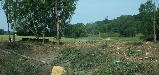
Continuing on past the downstream section, Hugh showed me the upper section that will pass through the cleared forestry plantation. Many native mature broadleaved trees such as birch that were seeding were left in the plantation when the conifers were harvested to help regenerate the native woodland there. However, competing for light against the densely planted conifers had made a lot of them look quite unstable with thin trunks. The route for the upper section is to follow the ditch that currently goes through the plantation and may be a remnant of the river before it was channelised. The new course in the upper section will be constructed in a similar manner as the downstream section to create a natural river course, as opposed to the current ditch.
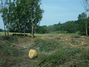
The new river section will cut across the field from the logs on the far right to the cows on the left before joining up with the ditch in the plantation. The current river is beside the logs.
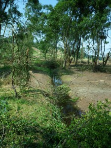
On the way back down Hugh showed me where the water is diverted away from the old channel down a ditch at the top of the lower section. As little water as possible is desired in both the old river course and the new river course so gravel removal and river course profiling work can be carried out with ease.
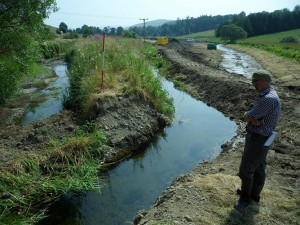
Hugh standing by the ditch that redirects the current river water, the old river course on the left and the new river course on the right are both cut off from the current rivers water supply.
Why carry out all this work? The old channelised river course was straight with embankments which meant that the water passed through the area very fast and only had access to the floodplain in only the most extreme flood occurrences therefore contributing to flood risk downstream. The embankments also meant that when water overtopped them in a flood, the water couldn’t re-enter the river when the flood subsided, causing problems for the landowners that farmed the land. The new river course on the other hand will have a longer route and easier access to the floodplain which will hold flood water more often, therefore slowing the passage of flood water through the same area more frequently. In addition to mitigating flooding downstream it will also allow the water to re-enter the river when the flood subsides, and therefore allow the farmers to use their fields sooner after flooding.
I have never seen the construction of a new river course before, so it was a very interesting day spent learning how the work is carried out. I’m looking forward to seeing this site when the work is complete, and the vegetation has recovered. Hopefully there is potential for something similar on the Allan Water!

